🏭 Heritage-listed building
Built: c.1740 · NIAH rating: Regional
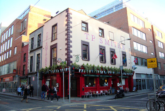
This public house incorporated two eighteenth-century houses, Nos.9 and 10 Jervis Street, which were used as tenements (No.9) and a grocers (No.10) in 1850. By 1870 Nos.9 and 10 were both occupied by Nicholas Behan grocer and spirit dealer, so it can be assumed the joined premises took on the function of a public house at this time. The proportions and window arrangement are a valuable reminder of the former residential function of these buildings and are a very rare survival of the eighteenth-century fabric of Jervis Street. The three-storey pub is now completely dwarfed by the Jervis Centre to the north, apartment complexes to the east and south, and a multi-storey car park to the west. Jervis Street was named after Humphrey Jervis, Lord Mayor of Dublin in 1681-3, who laid out the area around Saint Marys Abbey after buying much of this estate in 1674. Jervis developed a network of streets arranged in a nine-square grid, including Jervis Street, Stafford Street (now Wolfe Tone Street), and Capel Street, as well as building Essex Bridge. Jervis Street was once occupied by late seventeenth-century and early eighteenth-century gabled houses and Rocques map of 1756 shows terraced houses at the junction of Swift's Row and Jervis Street. The Jervis Street Hospital was founded north of Nos.9 and 10 in 1718, a plain brick hospital building was erected in 1803 was replaced in 1885 by a nine-bay four-storey building by Charles Geoghegan of red brick over a limestone base.
View NIAH recordIs this your pub?
Claim this listing to correct your details, update your opening hours, add photos, or list your trad sessions. Basic claim is free.
Claim this listing